
Carte topographique Thousand Oaks
Carte interactive
Cliquez sur la carte pour afficher l’altitude.
À propos de cette carte
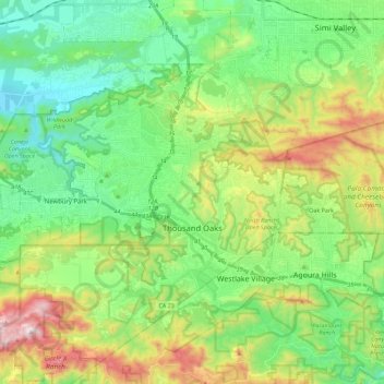
Nom : Carte topographique Thousand Oaks, altitude, relief.
Altitude moyenne : 333 m
Altitude minimum : 62 m
Altitude maximum : 918 m
The northern parts consist of mountainous terrain in the Simi Hills, Conejo Mountains and Mount Clef Ridge. Narrow canyons such as Hill Canyon cut through the steeper mountainous areas. Conejo Mountain and Conejo Grade are found in westernmost Newbury Park, while the southernmost parts of Thousand Oaks are made up of Russell Valley, Hidden Valley and the steep rugged slopes of the Santa Monica Mountains. The elevation ranges from 500 feet in the northwest to the 2,403 feet Simi Peak. The major drainage is Conejo Creek (Arroyo Conejo).
Autres cartes topographiques
Cliquez sur une carte pour visualiser sa topographie, son altitude et son relief.
Simi Valley
United States > California > Ventura County
Simi Valley, Ventura County, CAL Fire Contract Counties, California, United States
Altitude moyenne : 405 m
Santa Susana
United States > California > Ventura County > Simi Valley
Santa Susana, Simi Valley, Ventura County, California, 93064, United States
Altitude moyenne : 324 m
Ventura
United States > California > Ventura County
Ventura, Ventura County, CAL Fire Contract Counties, California, United States
Altitude moyenne : 134 m
Oak Park
United States > California > Ventura County
Oak Park, Ventura County, CAL Fire Southern Region, California, 91377, United States
Altitude moyenne : 378 m
Camarillo
United States > California > Ventura County
Camarillo, Ventura County, California, United States
Altitude moyenne : 90 m
Channel Islands National Park
United States > California > Ventura County
Channel Islands National Park, Ventura County, California, United States
Altitude moyenne : 6 m