
Carte topographique North
Carte interactive
Cliquez sur la carte pour afficher l’altitude.
À propos de cette carte
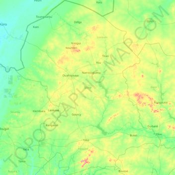
Nom : Carte topographique North, altitude, relief.
Lieu : North, Burkina Faso (12.62303 -2.95249 14.29945 -1.53208)
Altitude moyenne : 311 m
Altitude minimum : 256 m
Altitude maximum : 545 m
Most of Burkino Faso is a wide plateau formed by riverine systems and is called falaise de Banfora. There are three major rivers, the Red Volta, Black Volta and White Volta, which cuts through different valleys. The climate is generally hot, with unreliable rains across different seasons. Gold and quartz are common minerals found across the country, while manganese deposits are also common. The dry season is usually from October to May and rains are common during the wet season from June to September. The soil texture is porous and hence the yield is also poor. The average elevation is around 200 m (660 ft) to 300 m (980 ft) above mean sea level. Among West African countries, Burkino Faso has the largest elephant population and the country is replete with game reserves. The northern regions are generally arid and usually have scrub land and semi-deserts. The principal river is the Red Volta, that originates in the northern region and drains into Ghana. The areas near the rivers usually have flies like tsetse and similium, which are carriers of sleep sickness and river blindness. The average rainfall in the region is around 25 cm (9.8 in) compared to southern regions that receive only 100 cm (39 in) rainfall.
Autres cartes topographiques
Cliquez sur une carte pour visualiser sa topographie, son altitude et son relief.
Koala
Koala, Nagréongo, Oubritenga, Central-Plateau, Burkina Faso
Altitude moyenne : 289 m
Koupéla
Koupéla, Sabou, Boulkiemdé, Central-West, Burkina Faso
Altitude moyenne : 293 m
Petebarabe
Petebarabe, Falagountou, Séno, Sahel, Burkina Faso
Altitude moyenne : 265 m
Fada N'Gourma
Fada N'Gourma, Gourma, East, Burkina Faso
Altitude moyenne : 302 m