
Carte topographique Attendorn
Carte interactive
Cliquez sur la carte pour afficher l’altitude.
Attendorn
The town of Attendorn lies in the Naturpark Ebbegebirge, right on the Biggesee (lake) in the district's northwest. The town's highest point is the Rüenhardt (636 m), whereas the Ahauser Stausee (reservoir) has an elevation of only 248 m. The municipal area comprises 97 km², roughly half of which is wooded. It is a part of South Westphalia.
À propos de cette carte
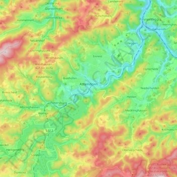
Nom : Carte topographique Attendorn, altitude, relief.
Lieu : Attendorn, Kreis Olpe, North Rhine-Westphalia, 57439, Germany (51.07271 7.79579 51.17069 8.00401)
Altitude moyenne : 384 m
Altitude minimum : 229 m
Altitude maximum : 630 m
Autres cartes topographiques
Cliquez sur une carte pour visualiser sa topographie, son altitude et son relief.
Altfinnentrop
Germany > North Rhine-Westphalia > Kreis Olpe > Finnentrop > Heggen
Altitude moyenne : 316 m
Rüblinghausen
Germany > North Rhine-Westphalia > Kreis Olpe > Olpe > Rüblinghausen
Altitude moyenne : 371 m