
Carte topographique Dylewska Góra
Carte interactive
Cliquez sur la carte pour afficher l’altitude.
Dylewska Góra
Dylewska Góra (German: Kernsdorfer Höhe) is a hill located in northeastern Poland, south of the town of Ostróda, in the Warmian-Masurian Voivodeship. With elevation of 312 metres above sea level, it is one of the highest points of northern and central Poland. Dylewska Góra is a morainic hill, with its eastern and northern slopes covered by beech forest. On top there is a TV tower, as well as a 37-metre-high observation tower, which provides views of area up to 50 kilometres away.
À propos de cette carte
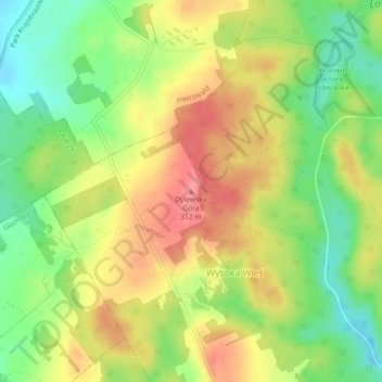
Nom : Carte topographique Dylewska Góra, altitude, relief.
Altitude moyenne : 269 m
Altitude minimum : 227 m
Altitude maximum : 311 m