
Carte topographique Waverly
Carte interactive
Cliquez sur la carte pour afficher l’altitude.
À propos de cette carte
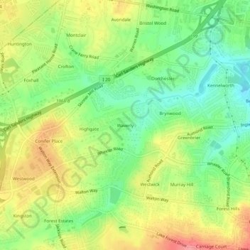
Nom : Carte topographique Waverly, altitude, relief.
Altitude moyenne : 96 m
Altitude minimum : 54 m
Altitude maximum : 146 m
Autres cartes topographiques
Cliquez sur une carte pour visualiser sa topographie, son altitude et son relief.
Bonair
United States > Georgia > Richmond County > Augusta
Bonair, Augusta, Richmond County, Georgia, 30990, United States
Altitude moyenne : 84 m
Bel Air Heights
United States > Georgia > Richmond County > Augusta
Bel Air Heights, Augusta, Richmond County, Georgia, 30905, United States
Altitude moyenne : 118 m
Fort Gordon
United States > Georgia > Richmond County > Augusta
Fort Gordon, Augusta, Richmond County, Georgia, 30905, United States
Altitude moyenne : 136 m
Berckman Villas
United States > Georgia > Richmond County > Augusta
Berckman Villas, Augusta, Richmond County, Georgia, 30904, United States
Altitude moyenne : 87 m
Nixon
United States > Georgia > Richmond County > Augusta
Nixon, Augusta, Richmond County, Georgia, United States
Altitude moyenne : 45 m
Marion Homes
United States > Georgia > Richmond County > Augusta
Marion Homes, Augusta, Richmond County, Georgia, 30901, United States
Altitude moyenne : 44 m
Soil Erosion Lake Dam
United States > Georgia > Richmond County > Augusta
Soil Erosion Lake Dam, Augusta, Richmond County, Georgia, 30905, United States
Altitude moyenne : 123 m
Kennelworth
United States > Georgia > Richmond County > Augusta
Kennelworth, Augusta, Richmond County, Georgia, 30909, United States
Altitude moyenne : 87 m
Windsor Court
United States > Georgia > Richmond County > Augusta
Windsor Court, Augusta, Richmond County, Georgia, 30904, United States
Altitude moyenne : 66 m
Goshen Plantation
United States > Georgia > Richmond County > Augusta > Goshen Plantation
Goshen Plantation, Augusta, Richmond County, Georgia, United States
Altitude moyenne : 73 m
Ridgewood
United States > Georgia > Richmond County > Augusta > Ridgewood
Ridgewood, Augusta, Richmond County, Georgia, 30909, United States
Altitude moyenne : 103 m