
Carte topographique Peloponnes, Westgriechenland und Ionische Inseln
Carte interactive
Cliquez sur la carte pour afficher l’altitude.
À propos de cette carte
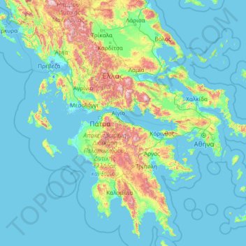
Nom : Carte topographique Peloponnes, Westgriechenland und Ionische Inseln, altitude, relief.
Lieu : Peloponnes, Westgriechenland und Ionische Inseln, Griechenland (36.28641 19.24779 40.00186 23.45462)
Altitude moyenne : 215 m
Altitude minimum : -7 m
Altitude maximum : 2 467 m
Autres cartes topographiques
Cliquez sur une carte pour visualiser sa topographie, son altitude et son relief.
Patras
Griechenland > Peloponnes, Westgriechenland und Ionische Inseln > Regionalbezirk Achaia
Patras, Regionalbezirk Achaia, Region Westgriechenland, Peloponnes, Westgriechenland und Ionische Inseln, Griechenland
Altitude moyenne : 291 m
Kalavros
Griechenland > Peloponnes, Westgriechenland und Ionische Inseln > Regionalbezirk Lefkada > Δημοτική Ενότητα Λευκάδος
Kalavros, Δημοτική Ενότητα Λευκάδος, Δήμος Λευκάδας, Regionalbezirk Lefkada, Region der Ionischen Inseln, Peloponnes, Westgriechenland und Ionische Inseln, 311 00, Griechenland
Altitude moyenne : 224 m
Korfu
Griechenland > Peloponnes, Westgriechenland und Ionische Inseln > Regionalbezirk Korfu
Korfu, Δήμος Κεντρικής Κέρκυρας και Διαποντίων Νήσων, Regionalbezirk Korfu, Region der Ionischen Inseln, Peloponnes, Westgriechenland und Ionische Inseln, 491 00, Griechenland
Altitude moyenne : 67 m
Korfu
Griechenland > Peloponnes, Westgriechenland und Ionische Inseln > Korfu
Korfu, Δήμος Κέρκυρας, Regionalbezirk Korfu, Region der Ionischen Inseln, Peloponnes, Westgriechenland und Ionische Inseln, 49100, Griechenland
Altitude moyenne : 41 m
Evinos
Griechenland > Peloponnes, Westgriechenland und Ionische Inseln
Evinos, Δήμος Θέρμου, Regionalbezirk Ätolien-Akarnanien, Region Westgriechenland, Peloponnes, Westgriechenland und Ionische Inseln, 30014, Griechenland
Altitude moyenne : 539 m
Kremasta-Stausee
Griechenland > Peloponnes, Westgriechenland und Ionische Inseln > Τρίκλινο
Kremasta-Stausee, Γέφυρα Βέργας - Δυτική Φραγκίστα, Κοινότητα Τρίκλινου, Τρίκλινο, Δήμος Αμφιλοχίας, Regionalbezirk Ätolien-Akarnanien, Region Westgriechenland, Peloponnes, Westgriechenland und Ionische Inseln, 30017, Griechenland
Altitude moyenne : 519 m
Stratos-Stausee
Griechenland > Peloponnes, Westgriechenland und Ionische Inseln > Αλώνια
Stratos-Stausee, Καλύβια - Γεφ. Σπολάιτας, Παλιάμπελα, Κοινότητα Σπολάιτας, Αλώνια, Δήμος Αγρινίου, Regionalbezirk Ätolien-Akarnanien, Region Westgriechenland, Peloponnes, Westgriechenland und Ionische Inseln, Griechenland
Altitude moyenne : 138 m
Kastraki-Stausee
Griechenland > Peloponnes, Westgriechenland und Ionische Inseln > Νέο Γιαννόπουλο
Kastraki-Stausee, Στράτος - Πατιόπουλο, Κοινότητα Μπαμπαλιού, Νέο Γιαννόπουλο, Δήμος Αμφιλοχίας, Regionalbezirk Ätolien-Akarnanien, Region Westgriechenland, Peloponnes, Westgriechenland und Ionische Inseln, 30018, Griechenland
Altitude moyenne : 309 m