
Carte topographique Лазац
Carte interactive
Cliquez sur la carte pour afficher l’altitude.
À propos de cette carte
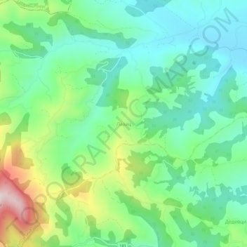
Nom : Carte topographique Лазац, altitude, relief.
Lieu : Лазац, Рашки управни округ, Serbie centrale, Serbie (43.71414 20.45035 43.75414 20.49035)
Altitude moyenne : 409 m
Altitude minimum : 270 m
Altitude maximum : 736 m
Autres cartes topographiques
Cliquez sur une carte pour visualiser sa topographie, son altitude et son relief.
Kraljevo
Serbie > Serbie centrale > Рашки управни округ
Kraljevo, Рашки управни округ, Serbie centrale, Serbie
Altitude moyenne : 611 m
Плешин
Serbie > Serbie centrale > Рашки управни округ > Општина Рашка
Плешин, Општина Рашка, Рашки управни округ, Serbie centrale, Serbie
Altitude moyenne : 1 241 m
Маглич
Serbie > Serbie centrale > Рашки управни округ > Kraljevo
Маглич, Стаза Маглич-Чикер, Замчање, Kraljevo, Рашки управни округ, Serbie centrale, Serbie
Altitude moyenne : 452 m
Долово
Serbie > Serbie centrale > Рашки управни округ > Општина Тутин
Долово, Општина Тутин, Рашки управни округ, Serbie centrale, Serbie
Altitude moyenne : 1 148 m