
Carte topographique maloti
Carte interactive
Cliquez sur la carte pour afficher l’altitude.
À propos de cette carte
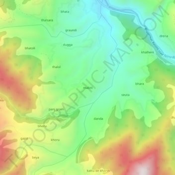
Nom : Carte topographique maloti, altitude, relief.
Lieu : maloti, Bhaderwah, Doda district, Jammu and Kashmir, India (33.02878 75.58911 33.06878 75.62911)
Altitude moyenne : 1 525 m
Altitude minimum : 1 194 m
Altitude maximum : 2 058 m
Autres cartes topographiques
Cliquez sur une carte pour visualiser sa topographie, son altitude et son relief.
dhalla
India > Jammu and Kashmir > Bhaderwah > dhalla
dhalla, Bhaderwah, Doda District, Jammu and Kashmir, India
Altitude moyenne : 2 097 m