
Faire un don
Équipez-vous pour votre prochaine aventure :
En tant que Partenaire Amazon, ce site perçoit une commission sur les achats éligibles sans surcoût pour vous.
Carte topographique Baker
Cliquez sur la carte pour afficher l’altitude.
Faire un don
Équipez-vous pour votre prochaine aventure :
En tant que Partenaire Amazon, ce site perçoit une commission sur les achats éligibles sans surcoût pour vous.
À propos de cette carte
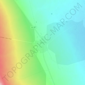
Nom : Carte topographique Baker, altitude, relief.
Lieu : Baker, White Pine County, Nevada, 89311, United States (38.99218 -114.14333 39.03218 -114.10333)
Altitude moyenne : 1 632 m
Altitude minimum : 1 577 m
Altitude maximum : 1 755 m
Faire un don
Équipez-vous pour votre prochaine aventure :
En tant que Partenaire Amazon, ce site perçoit une commission sur les achats éligibles sans surcoût pour vous.
Autres cartes topographiques
Cliquez sur une carte pour visualiser sa topographie, son altitude et son relief.
Ely
United States > Nevada > White Pine County
Ely experiences a semi-arid climate (Köppen BSk), and extreme day-night temperature differences year-round. Ely's nighttime temperatures account for it being listed as one of the coldest places in the contiguous United States, with an average of 214.9 nights per year with a minimum temperature of 32 °F (0…
Altitude moyenne : 2 045 m
Great Basin National Park
United States > Nevada > White Pine County
The park derives its name from the Great Basin, the dry and mountainous region between the Sierra Nevada and the Wasatch Mountains. Topographically, this area is known as the Basin and Range Province. The park is located about 290 miles (470 km) north of Las Vegas and protects 77,180 acres (31,230 ha).
Altitude moyenne : 2 352 m
Snake Range
United States > Nevada > White Pine County
The Snake Range is a mountain range in White Pine County, Nevada, United States. The south-central portion of the range is included within Great Basin National Park, with most of the remainder included within the Humboldt-Toiyabe National Forest. The range reaches a maximum elevation of 13,065 feet (3,982 m)…
Altitude moyenne : 1 996 m
Great Basin National Park
United States > Nevada > White Pine County
The park derives its name from the Great Basin, the dry and mountainous region between the Sierra Nevada and the Wasatch Mountains. Topographically, this area is known as the Basin and Range Province. The park is located about 290 miles (470 km) north of Las Vegas and protects 77,180 acres (31,230 ha).
Altitude moyenne : 2 352 m
Faire un don
Équipez-vous pour votre prochaine aventure :
En tant que Partenaire Amazon, ce site perçoit une commission sur les achats éligibles sans surcoût pour vous.
Ely
United States > Nevada > White Pine County
Ely experiences a semi-arid climate (Köppen BSk), and extreme day-night temperature differences year-round. Ely's nighttime temperatures account for it being listed as one of the coldest places in the contiguous United States, with an average of 214.9 nights per year with a minimum temperature of 32 °F (0…
Altitude moyenne : 2 045 m