
Carte topographique Atua
Carte interactive
Cliquez sur la carte pour afficher l’altitude.
À propos de cette carte
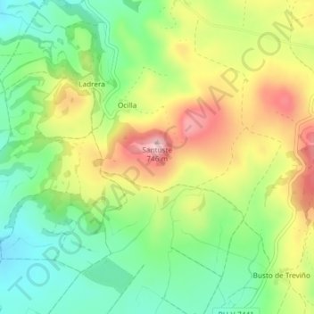
Nom : Carte topographique Atua, altitude, relief.
Altitude moyenne : 629 m
Altitude minimum : 543 m
Altitude maximum : 744 m
Autres cartes topographiques
Cliquez sur une carte pour visualiser sa topographie, son altitude et son relief.
La Sierra
Spain > Castile and León > Condado de Treviño
La Sierra, Condado de Treviño, Burgos, Castile and León, Spain
Altitude moyenne : 886 m
La Sierra
Spain > Castile and León > Condado de Treviño
La Sierra, Condado de Treviño, Ebro, Burgos, Castile and León, Spain
Altitude moyenne : 790 m
Santa Cruz
Spain > Castile and León > Condado de Treviño
Santa Cruz, Condado de Treviño, Ebro, Burgos, Castile and León, Spain
Altitude moyenne : 670 m
San Juan
Spain > Castile and León > Condado de Treviño
San Juan, Condado de Treviño, Ebro, Burgos, Castile and León, Spain
Altitude moyenne : 649 m