
Carte topographique Komańcza
Carte interactive
Cliquez sur la carte pour afficher l’altitude.
À propos de cette carte
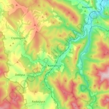
Nom : Carte topographique Komańcza, altitude, relief.
Altitude moyenne : 564 m
Altitude minimum : 398 m
Altitude maximum : 779 m
Autres cartes topographiques
Cliquez sur une carte pour visualiser sa topographie, son altitude et son relief.
Lalin
Poland > Subcarpathian Voivodeship > Sanok County
Lalin, gmina Sanok, Sanok County, Subcarpathian Voivodeship, Poland
Altitude moyenne : 350 m
Sanok
Poland > Subcarpathian Voivodeship > Sanok County > Sanok
Sanok, Sanok County, Subcarpathian Voivodeship, Poland
Altitude moyenne : 354 m
Falejówka
Poland > Subcarpathian Voivodeship > Sanok County
Falejówka, gmina Sanok, Sanok County, Subcarpathian Voivodeship, Poland
Altitude moyenne : 379 m