
Carte topographique Ketchikan
Carte interactive
Cliquez sur la carte pour afficher l’altitude.
Ketchikan
Due to its steep and forested terrain, Ketchikan is long and narrow with much of the built-up area being located along, or no more than a few city blocks from, the waterfront. Elevations of inhabited areas range from just above sea level to about 300 feet (91 m). Deer Mountain, a 3,001-foot (915 m) peak, rises immediately east of the city's downtown area.
À propos de cette carte
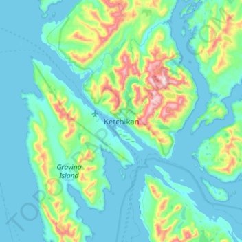
Nom : Carte topographique Ketchikan, altitude, relief.
Altitude moyenne : 150 m
Altitude minimum : -13 m
Altitude maximum : 1 027 m