
Faire un don
Équipez-vous pour votre prochaine aventure :
En tant que Partenaire Amazon, ce site perçoit une commission sur les achats éligibles sans surcoût pour vous.
Carte topographique Bhuj Taluka
Cliquez sur la carte pour afficher l’altitude.
Faire un don
Équipez-vous pour votre prochaine aventure :
En tant que Partenaire Amazon, ce site perçoit une commission sur les achats éligibles sans surcoût pour vous.
À propos de cette carte
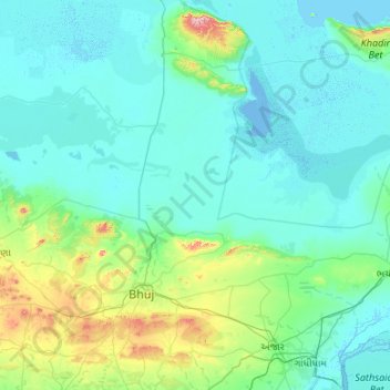
Nom : Carte topographique Bhuj Taluka, altitude, relief.
Lieu : Bhuj Taluka, Kachchh, Gujarat, India (23.00201 69.16434 23.98374 70.18822)
Altitude moyenne : 46 m
Altitude minimum : -6 m
Altitude maximum : 440 m
Faire un don
Équipez-vous pour votre prochaine aventure :
En tant que Partenaire Amazon, ce site perçoit une commission sur les achats éligibles sans surcoût pour vous.
Autres cartes topographiques
Cliquez sur une carte pour visualiser sa topographie, son altitude et son relief.
Bhuj
India > Gujarat > Bhuj Taluka
Bhuj has an average elevation of 110 metres (360 feet). On the eastern side of the city is a hill known as Bhujia Hill, on which there is a Bhujia Fort, that separates Bhuj city and Madhapar town ( considered one of the richest villages in Asia ). It has two lakes namely Hamirsar and Deshadsar (દેેેશળસર).
Altitude moyenne : 130 m
Faire un don
Équipez-vous pour votre prochaine aventure :
En tant que Partenaire Amazon, ce site perçoit une commission sur les achats éligibles sans surcoût pour vous.
Bhuj
India > Gujarat > Bhuj Taluka
Bhuj has an average elevation of 110 metres or 360 feet. On the eastern side of the city is a hill known as Bhujia Hill, on which there is a Bhujia Fort, that separates Bhuj city and Madhapar town (considered one of the richest villages in Asia). It has two lakes namely Hamirsar Lake and Deshadsar (દેેેશળસર).
Altitude moyenne : 130 m
Bhuj
India > Gujarat > Bhuj Taluka
Bhuj has an average elevation of 110 metres (360 feet). On the eastern side of the city is a hill known as Bhujia Hill, on which there is a Bhujia Fort, that separates Bhuj city and Madhapar town ( considered one of the richest villages in Asia ). It has two lakes namely Hamirsar and Deshadsar (દેેેશળસર).
Altitude moyenne : 130 m
Faire un don
Équipez-vous pour votre prochaine aventure :
En tant que Partenaire Amazon, ce site perçoit une commission sur les achats éligibles sans surcoût pour vous.
Bhuj
India > Gujarat > Bhuj Taluka
Bhuj has an average elevation of 110 metres (360 feet). On the eastern side of the city is a hill known as Bhujia Hill, on which there is a Bhujia Fort, that separates Bhuj city and Madhapar town ( considered one of the richest villages in Asia ). It has two lakes namely Hamirsar Lake and Deshadsar (દેેેશળસર).
Altitude moyenne : 130 m
Faire un don
Équipez-vous pour votre prochaine aventure :
En tant que Partenaire Amazon, ce site perçoit une commission sur les achats éligibles sans surcoût pour vous.