
Carte topographique Hergest Ridge
Cliquez sur la carte pour afficher l’altitude.
Hergest Ridge
Hergest Ridge is a large elongated hill which traverses the border between England and Wales in the United Kingdom, between the town of Kington in Herefordshire and the village of Gladestry in Powys. Its highest point, which is in England, is 426 metres (1,398 ft) high. It has a topographic prominence of 157.6 metres (517 ft) and thus is listed as a Marilyn.
À propos de cette carte
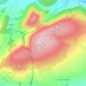
Nom : Carte topographique Hergest Ridge, altitude, relief.
Lieu : Hergest Ridge, Herefordshire, England, HR5 3EP, United Kingdom (52.19933 -3.09072 52.19943 -3.09062)
Altitude moyenne : 308 m
Altitude minimum : 176 m
Altitude maximum : 425 m
Autres cartes topographiques
Cliquez sur une carte pour visualiser sa topographie, son altitude et son relief.
Croft Castle
United Kingdom > England > Herefordshire > Yarpole
The present building dates from the 1660s during the time when Herbert Croft was Bishop of Hereford, replacing an earlier house some thirty yards to the west, which was excavated by Herefordshire County Archaeologist Prof. Keith Ray and volunteers in 2002. The manor house is a quadrangular stone structure…
Altitude moyenne : 173 m
Eastnor Deer Park
United Kingdom > England > Herefordshire > Eastnor > Wayend Street
Altitude moyenne : 134 m