
Carte topographique Paipa
Carte interactive
Cliquez sur la carte pour afficher l’altitude.
À propos de cette carte
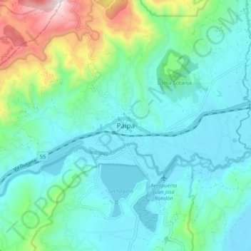
Nom : Carte topographique Paipa, altitude, relief.
Lieu : Paipa, Tundama, Boyacá, 150440, Colombia (5.74128 -73.15765 5.82128 -73.07765)
Altitude moyenne : 2 641 m
Altitude minimum : 2 477 m
Altitude maximum : 3 263 m
Paipa is located 15 km west of Duitama and 48 kilometres (30 mi) to the northeast of Tunja, the capital of the department, in the Cordillera Oriental (Eastern Ranges) of the Colombian Andes. It is the main tourist center of the region, with a number of large hotels and hot springs. At an elevation of 2525 m, the climate is mild with an average of 14° Celsius.