
Faire un don
Équipez-vous pour votre prochaine aventure :
En tant que Partenaire Amazon, ce site perçoit une commission sur les achats éligibles sans surcoût pour vous.
Carte topographique Dhulikhel
Cliquez sur la carte pour afficher l’altitude.
Faire un don
Équipez-vous pour votre prochaine aventure :
En tant que Partenaire Amazon, ce site perçoit une commission sur les achats éligibles sans surcoût pour vous.
À propos de cette carte
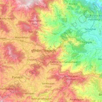
Nom : Carte topographique Dhulikhel, altitude, relief.
Lieu : Dhulikhel, Kavrepalanchok, Bagamati Province, Nepal (27.55370 85.53047 27.68175 85.62797)
Altitude moyenne : 1 369 m
Altitude minimum : 754 m
Altitude maximum : 2 018 m
Faire un don
Équipez-vous pour votre prochaine aventure :
En tant que Partenaire Amazon, ce site perçoit une commission sur les achats éligibles sans surcoût pour vous.
Autres cartes topographiques
Cliquez sur une carte pour visualiser sa topographie, son altitude et son relief.
Faire un don
Équipez-vous pour votre prochaine aventure :
En tant que Partenaire Amazon, ce site perçoit une commission sur les achats éligibles sans surcoût pour vous.
Nagarkot
Nepal > Bagamati Province > Kavrepalanchok
Nagarkot (Nepali: नगरकोट) is a former village development committee located 32 km east of Kathmandu, Nepal, in Bhaktapur District in Bagmati Province and as of 2015 part of Nagarkot Municipality. At the time of the 2011 census it had a population of 4,571 and had 973 houses in it. At an elevation…
Altitude moyenne : 1 679 m
Nagarkot
Nepal > Bagamati Province > Kavrepalanchok
At the time of the 2021 census it had a population of 5,234 and had 1,084 houses in it. At an elevation of 2,195 meters, it is considered one of the most scenic spots in Bhaktapur District. Nagarkot also offers views of the Kathmandu Valley. The scenery of the place makes it a popular hiking route for…
Altitude moyenne : 1 679 m
Faire un don
Équipez-vous pour votre prochaine aventure :
En tant que Partenaire Amazon, ce site perçoit une commission sur les achats éligibles sans surcoût pour vous.
Panorama of Banepa Valley & Himalaya Mountains
Nepal > Bagamati Province > Kavrepalanchok
Altitude moyenne : 1 611 m
Faire un don
Équipez-vous pour votre prochaine aventure :
En tant que Partenaire Amazon, ce site perçoit une commission sur les achats éligibles sans surcoût pour vous.