
Carte topographique Needham
Carte interactive
Cliquez sur la carte pour afficher l’altitude.
Needham
Needham's area is roughly in the shape of an acute, northward-pointing triangle. The Charles River forms nearly all of the southern and northeastern boundaries, the town line with Wellesley forming the third, northwestern one. In addition to Wellesley on the northwest, Needham borders Newton and the West Roxbury section of Boston on the northeast, and Dover, Westwood, and Dedham on the south. The majority of Cutler Park is in Needham and is located along the Charles River and the border with Newton and West Roxbury. Needham's elevation is at sea level, but is a very hilly town.
À propos de cette carte
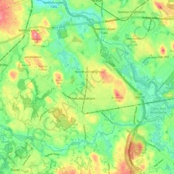
Nom : Carte topographique Needham, altitude, relief.
Altitude moyenne : 46 m
Altitude minimum : 11 m
Altitude maximum : 98 m