
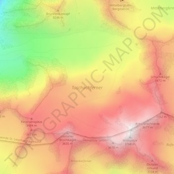
Carte topographique Taschachferner
Carte interactive
Cliquez sur la carte pour afficher l’altitude.
À propos de cette carte
Nom : Carte topographique Taschachferner, altitude, relief.
Altitude moyenne : 3 208 m
Altitude minimum : 2 545 m
Altitude maximum : 3 733 m
Autres cartes topographiques
Cliquez sur une carte pour visualiser sa topographie, son altitude et son relief.
Waze
Österreich > Tirol > St. Leonhard im Pitztal
Waze, St. Leonhard im Pitztal, Imst, Tirol, Österreich
Altitude moyenne : 2 932 m
Rostizkogel
Österreich > Tirol > St. Leonhard im Pitztal
Rostizkogel, St. Leonhard im Pitztal, Imst, Tirol, Österreich
Altitude moyenne : 2 936 m
Verpeilspitze
Österreich > Tirol > St. Leonhard im Pitztal
Verpeilspitze, St. Leonhard im Pitztal, Imst, Tirol, Österreich
Altitude moyenne : 2 848 m
Mittelbergferner
Österreich > Tirol > St. Leonhard im Pitztal
Mittelbergferner, BIG3 Aussichtsplattform, St. Leonhard im Pitztal, Imst, Tirol, 6481, Österreich
Altitude moyenne : 2 976 m