
Carte topographique Wild Horse Island
Carte interactive
Cliquez sur la carte pour afficher l’altitude.
À propos de cette carte
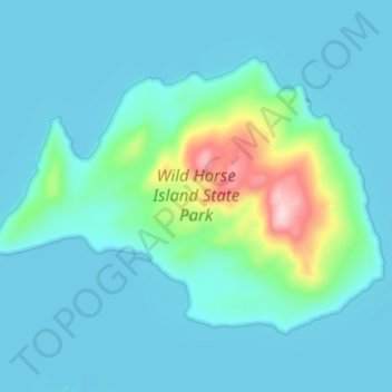
Nom : Carte topographique Wild Horse Island, altitude, relief.
Lieu : Wild Horse Island, Lake County, Montana, United States (47.82879 -114.24866 47.85777 -114.18785)
Altitude moyenne : 916 m
Altitude minimum : 879 m
Altitude maximum : 1 139 m
The island was formed by the Cordilleran Glacier, giving the island a varying topography. Its shores are 2,900 feet (880 m) above sea level. The glacier caused the six summits in the center of the island, ranging in heights between 3,277 and 3,745 feet (999 and 1,141 m), to be formed into rôche moutonnée, with rugged northern faces and rugged southern cliffs. Meadows sprawl the western and southern shores, while grasslands cover the southeast. The northern side of the island has forests of Ponderosa pine and Douglas fir trees. The highest point is at 3,749 feet (1,143 m), which is 853 feet (260 m) above the island's shores.
Autres cartes topographiques
Cliquez sur une carte pour visualiser sa topographie, son altitude et son relief.
Flathead Lake
United States > Montana > Lake County
Flathead Lake, Lake County, Montana, United States
Altitude moyenne : 1 168 m
Picture Lake
United States > Montana > Lake County
Picture Lake, Lake County, Montana, United States
Altitude moyenne : 2 220 m
Kicking Horse
United States > Montana > Lake County
Kicking Horse, Lake County, Montana, United States
Altitude moyenne : 938 m