
Carte topographique Castel Gandolfo
Carte interactive
Cliquez sur la carte pour afficher l’altitude.
À propos de cette carte
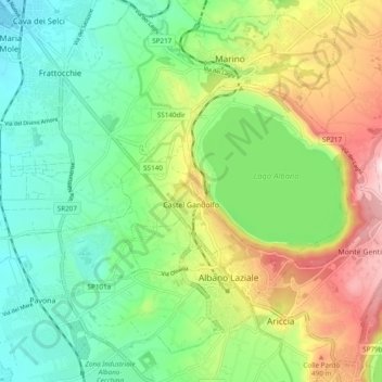
Nom : Carte topographique Castel Gandolfo, altitude, relief.
Lieu : Castel Gandolfo, Roma Capitale, Lazio, 00073, Italy (41.72476 12.59258 41.76520 12.68832)
Altitude moyenne : 306 m
Altitude minimum : 131 m
Altitude maximum : 633 m
The maximum elevation registered in the territory is 425 m (1,390 ft) above sea level, at the Collegio di Propaganda Fide adjoining Villa Barberini. On the crown of the hills around the Lake Albano, the elevation is only 400 m (1,300 ft) above sea level, at the summit of Monte Cucco, bordering Marino.
Autres cartes topographiques
Cliquez sur une carte pour visualiser sa topographie, son altitude et son relief.
Villa Borghese Park
Italy > Lazio > Roma Capitale > Rome
Villa Borghese Park, Rome, Roma Capitale, Lazio, Italy
Altitude moyenne : 52 m
Rome
Italy > Lazio > Roma Capitale > Rome
Rome, Roma Capitale, Lazio, 00100, Italy
Altitude moyenne : 78 m
Fiumicino
Italy > Lazio > Roma Capitale > Fiumicino
Fiumicino, Roma Capitale, Lazio, Italy
Altitude moyenne : 37 m