Géolocaliser

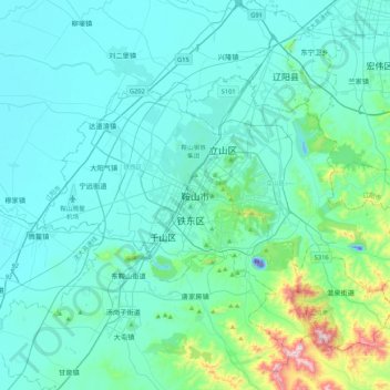
Carte topographique Anshan

Cliquez sur la carte pour afficher l’altitude.

Anshan

Local transportation is primarily by bus or taxi. Anshan used to have a single tram line—along Zhonghua Avenue, through the city centre and past Angang main gate—but this has been closed and the tracks removed. Due to the flat topography of the city centre, bicycles are popular. Almost all roads have a wide cycle lane on each side. Often this lane is further protected by a traffic island that separates the bikes from larger motor vehicles.

Wikipedia (CC-BY-SA 3.0)

À propos de cette carte

Nom : Carte topographique Anshan, altitude, relief.

Lieu : Anshan, Shengli Subdistrict, Tiedong District, Anshan City, Liaoning, China (40.94753 122.83027 41.26753 123.15027)

Altitude moyenne : 79 m

Altitude minimum : -53 m

Altitude maximum : 662 m

Équipez-vous pour votre prochaine aventure :

Montre Altimètre Baromètre - Capteurs ABC pour suivre l'élévation et la météo en temps réel
🚥Lumières Vélo LED - Visibilité et sécurité pour les retours tardifs
🔥Réchaud à Gaz Ultra-léger - Système de cuisson compact pour les repas en plein air
🧢Bonnet en Laine Mérinos - Régulation thermique naturelle pour les nuits froides
🦟Répulsif Insectes Fort - Protection efficace contre les tiques et moustiques en forêt

En tant que Partenaire Amazon, ce site perçoit une commission sur les achats éligibles sans surcoût pour vous.