
Carte topographique Three Sisters
Carte interactive
Cliquez sur la carte pour afficher l’altitude.
À propos de cette carte
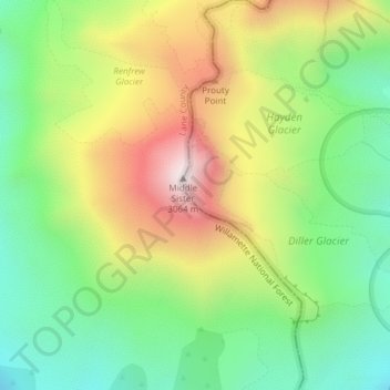
Nom : Carte topographique Three Sisters, altitude, relief.
Lieu : Three Sisters, Deschutes County, Oregon, United States (44.14716 -121.78299 44.14726 -121.78289)
Altitude moyenne : 2 526 m
Altitude minimum : 2 164 m
Altitude maximum : 3 046 m
The Three Sisters are closely spaced volcanic peaks in the U.S. state of Oregon. They are part of the Cascade Volcanic Arc, a segment of the Cascade Range in western North America extending from southern British Columbia through Washington and Oregon to Northern California. Each more than 10,000 feet (3,000 m) in elevation, they are the third-, fourth- and fifth-highest peaks in Oregon. Located in the Three Sisters Wilderness at the boundary of Lane and Deschutes counties and the Willamette and Deschutes national forests, they are about 10 miles (16 km) south of the nearest town, Sisters. Diverse species of flora and fauna inhabit the area, which is subject to frequent snowfall, occasional rain, and extreme temperature variation between seasons. The mountains, particularly South Sister, are popular destinations for climbing and scrambling.
Autres cartes topographiques
Cliquez sur une carte pour visualiser sa topographie, son altitude et son relief.
Sunriver
United States > Oregon > Deschutes County
Sunriver, Deschutes County, Oregon, 97707, United States
Altitude moyenne : 1 312 m
Lewis Glacier
United States > Oregon > Deschutes County
Lewis Glacier, Deschutes County, Oregon, United States
Altitude moyenne : 2 604 m
Sparks Lake
United States > Oregon > Deschutes County
Sparks Lake, Deschutes County, Oregon, United States
Altitude moyenne : 1 696 m
Bend
United States > Oregon > Deschutes County
Bend, Deschutes County, Oregon, United States
Altitude moyenne : 1 121 m