
Carte topographique Pershing County
Carte interactive
Cliquez sur la carte pour afficher l’altitude.
À propos de cette carte
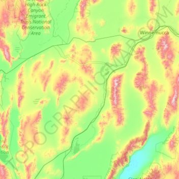
Nom : Carte topographique Pershing County, altitude, relief.
Lieu : Pershing County, Nevada, United States of America (39.99816 -119.33852 40.96106 -117.30002)
Altitude moyenne : 1 449 m
Altitude minimum : 1 029 m
Altitude maximum : 2 962 m
According to the U.S. Census Bureau, the county has a total area of 6,067 square miles (15,710 km2), of which 6,037 square miles (15,640 km2) is land and 31 square miles (80 km2) (0.5%) is water. The tallest and most topographically prominent mountain in Pershing County is Star Peak at 9,840 ft (3,000 m).
Autres cartes topographiques
Cliquez sur une carte pour visualiser sa topographie, son altitude et son relief.
Lincoln County
United States of America > Nevada
Lincoln County, Nevada, United States of America
Altitude moyenne : 1 639 m
Lander County
United States of America > Nevada
Lander County, Nevada, United States of America
Altitude moyenne : 1 768 m
Mesquite
United States of America > Nevada > Mesquite
Mesquite, Clark County, Nevada, United States of America
Altitude moyenne : 601 m
Whitney
United States of America > Nevada > Whitney
Whitney, Clark County, Nevada, United States of America
Altitude moyenne : 524 m
Clark County
United States of America > Nevada
Clark County, Nevada, United States of America
Altitude moyenne : 968 m
North Valley
United States of America > Nevada > Reno > North Valley
North Valley, Reno, Washoe County, Nevada, 89512, United States of America
Altitude moyenne : 1 419 m
Jackman
United States of America > Nevada > Jackman
Jackman, Clark County, Nevada, United States of America
Altitude moyenne : 506 m
Elko County
United States of America > Nevada
Elko County, Nevada, United States of America
Altitude moyenne : 1 838 m