
Carte topographique Elk City
Carte interactive
Cliquez sur la carte pour afficher l’altitude.
À propos de cette carte
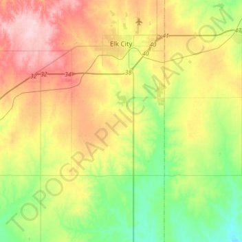
Nom : Carte topographique Elk City, altitude, relief.
Lieu : Elk City, Beckham County, Oklahoma, United States (35.24023 -99.63995 35.44341 -99.36420)
Altitude moyenne : 588 m
Altitude minimum : 507 m
Altitude maximum : 699 m
Elk City is located in northeastern Beckham County at 35°24′10″N 99°25′26″W / 35.40278°N 99.42389°W / 35.40278; -99.42389 (35.402694, -99.423812), elevation 1,928 feet (588 m).
Autres cartes topographiques
Cliquez sur une carte pour visualiser sa topographie, son altitude et son relief.
Texola
United States > Oklahoma > Beckham County
Texola, Beckham County, Oklahoma, 73668, United States
Altitude moyenne : 654 m
Sweetwater
United States > Oklahoma > Beckham County
Sweetwater, Beckham County, Oklahoma, 73666, United States
Altitude moyenne : 663 m
Erick
United States > Oklahoma > Beckham County
Erick, Beckham County, Oklahoma, 73645, United States
Altitude moyenne : 631 m
Sayre
United States > Oklahoma > Beckham County
Sayre, Beckham County, Oklahoma, 73662, United States
Altitude moyenne : 567 m
Sayre
United States > Oklahoma > Beckham County > Sayre > Sayre
Sayre, Beckham County, Oklahoma, 73662, United States
Altitude moyenne : 560 m
Sayre
United States > Oklahoma > Beckham County
Sayre, Beckham County, Oklahoma, 73662, United States
Altitude moyenne : 567 m