
Faire un don
Équipez-vous pour votre prochaine aventure :
En tant que Partenaire Amazon, ce site perçoit une commission sur les achats éligibles sans surcoût pour vous.
Carte topographique Campolongo
Cliquez sur la carte pour afficher l’altitude.
Faire un don
Équipez-vous pour votre prochaine aventure :
En tant que Partenaire Amazon, ce site perçoit une commission sur les achats éligibles sans surcoût pour vous.
À propos de cette carte
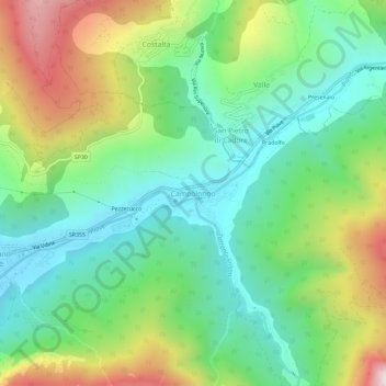
Nom : Carte topographique Campolongo, altitude, relief.
Altitude moyenne : 1 219 m
Altitude minimum : 904 m
Altitude maximum : 1 829 m
Faire un don
Équipez-vous pour votre prochaine aventure :
En tant que Partenaire Amazon, ce site perçoit une commission sur les achats éligibles sans surcoût pour vous.
Autres cartes topographiques
Cliquez sur une carte pour visualiser sa topographie, son altitude et son relief.
Cortina d'Ampezzo
Among the surrounding mountains are Tofane to the west, Pomagagnon to the north, Cristallo to the northeast, Faloria and Sorapiss to the east, and Becco di Mezzodì, Croda da Lago and Cinque Torri to the south. Monte Antelao (Nantelou in Ladin) is at 3264 m the highest mountain in the Ampezzo Dolomites and the…
Altitude moyenne : 1 974 m
Cortina d'Ampezzo
Among the surrounding mountains are Tofane to the west, Pomagagnon to the north, Cristallo to the northeast, Faloria and Sorapiss to the east, and Becco di Mezzodì, Croda da Lago and Cinque Torri to the south. Monte Antelao (Nantelou in Ladin) is at 3,264 m the highest mountain in the Ampezzo Dolomites and…
Altitude moyenne : 1 974 m
Cortina d'Ampezzo
Among the surrounding mountains are Tofane to the west, Pomagagnon to the north, Cristallo to the northeast, Faloria and Sorapiss to the east, and Becco di Mezzodì, Croda da Lago and Cinque Torri to the south. The town centre is located at an elevation of 1,224 metres (4,016 ft), although the highest summit…
Altitude moyenne : 1 974 m
Faire un don
Équipez-vous pour votre prochaine aventure :
En tant que Partenaire Amazon, ce site perçoit une commission sur les achats éligibles sans surcoût pour vous.
Parco Nazionale Dolomiti Bellunesi
The national park includes mountain ranges of Alpi Feltrine (Vette di Feltre, Cimonega, Pizzocco, Brendol, Agnelezze), Monti del Sole, Schiara, Talvena, Prampèr and Spiz di Mezzodì. There are high-altitude areas, karst rocks and debris slopes, ideal habitat for high-mountain species.
Altitude moyenne : 1 121 m
Faire un don
Équipez-vous pour votre prochaine aventure :
En tant que Partenaire Amazon, ce site perçoit une commission sur les achats éligibles sans surcoût pour vous.
Domegge di Cadore
The town is located in the Dolomites of the upper Piave valley, on the right bank of the river and at an altitude ranging from 655 m a.s.l. of the old part of the hamlet of Vallesella, up to 900 of the hamlet of Grea.
Altitude moyenne : 1 328 m
Faire un don
Équipez-vous pour votre prochaine aventure :
En tant que Partenaire Amazon, ce site perçoit une commission sur les achats éligibles sans surcoût pour vous.
Faire un don
Équipez-vous pour votre prochaine aventure :
En tant que Partenaire Amazon, ce site perçoit une commission sur les achats éligibles sans surcoût pour vous.
Marmolada
The ridge is composed of several summits, decreasing in altitude from west to east: Punta Penia 3,343 metres (10,968 ft), Punta Rocca 3,309 metres (10,856 ft), Punta Ombretta 3,230 metres (10,600 ft), Monte Serauta 3,069 metres (10,069 ft), and Pizzo Serauta 3,035 metres (9,957 ft). An aerial tramway goes to…
Altitude moyenne : 1 896 m
Faire un don
Équipez-vous pour votre prochaine aventure :
En tant que Partenaire Amazon, ce site perçoit une commission sur les achats éligibles sans surcoût pour vous.
Cortina d'Ampezzo
Among the surrounding mountains are Tofane to the west, Pomagagnon to the north, Cristallo to the northeast, Faloria and Sorapiss to the east, and Becco di Mezzodì, Croda da Lago and Cinque Torri to the south. Monte Antelao (Nantelou in Ladin) is at 3264 m the highest mountain in the Ampezzo Dolomites and the…
Altitude moyenne : 1 974 m
Tre Cime di Lavaredo - Drei Zinnen
Italy > Veneto > Belluno > Auronzo di Cadore
Until 1919 the peaks formed part of the border between Italy and Austria-Hungary. Now they lie on the border between the Italian provinces of South Tyrol and Belluno and still are a part of the linguistic boundary between German-speaking and Italian-speaking majorities. The Cima Grande has an elevation of…
Altitude moyenne : 2 242 m
Faire un don
Équipez-vous pour votre prochaine aventure :
En tant que Partenaire Amazon, ce site perçoit une commission sur les achats éligibles sans surcoût pour vous.
Faire un don
Équipez-vous pour votre prochaine aventure :
En tant que Partenaire Amazon, ce site perçoit une commission sur les achats éligibles sans surcoût pour vous.