
Carte topographique West Richland
Carte interactive
Cliquez sur la carte pour afficher l’altitude.
À propos de cette carte
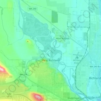
Nom : Carte topographique West Richland, altitude, relief.
Altitude moyenne : 146 m
Altitude minimum : 93 m
Altitude maximum : 424 m
The original people of the region were the Chemnapum Indians (closely related to the Wanapum tribe), living near the mouth of the Yakima River. Lewis and Clark passed through the area in 1805, and an expedition of the Army Corps of Topographical Engineers headed by Robert E Johnson mapped the Yakima Valley in 1841.
Autres cartes topographiques
Cliquez sur une carte pour visualiser sa topographie, son altitude et son relief.
Richland
United States > Washington > Benton County
Richland, Benton County, Washington, United States
Altitude moyenne : 160 m
Kennewick
United States > Washington > Benton County
Kennewick, Benton County, Washington, United States
Altitude moyenne : 154 m
Columbia Plateau
United States > Washington > Benton County
Columbia Plateau, Benton County, Washington, United States
Altitude moyenne : 221 m