
Carte topographique Kings Canyon National Park
Carte interactive
Cliquez sur la carte pour afficher l’altitude.
À propos de cette carte
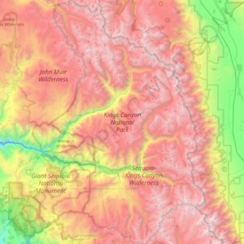
Nom : Carte topographique Kings Canyon National Park, altitude, relief.
Altitude moyenne : 2 591 m
Altitude minimum : 630 m
Altitude maximum : 4 372 m
Kings Canyon is characterized by some of the steepest vertical relief in North America, with numerous peaks over 14,000 feet (4,300 m) on the Sierra Crest along the park's eastern border, falling to 4,500 feet (1,400 m) in the valley floor of Cedar Grove just ten miles (16 km) to the west. The Sierran crest forms the eastern boundary of the park, from Mount Goethe in the north, down to Junction Peak, at the boundary with Sequoia National Park. Several passes cross the crest into the park, including Bishop Pass, Taboose Pass, Sawmill Pass, and Kearsarge Pass. All of these passes are above 11,000 feet (3,400 m) in elevation.
Autres cartes topographiques
Cliquez sur une carte pour visualiser sa topographie, son altitude et son relief.
Fresno
United States > California > Fresno County
Fresno, Fresno County, California, United States
Altitude moyenne : 98 m
Pinehurst
United States > California > Fresno County
Pinehurst, Fresno County, California, 93641, United States
Altitude moyenne : 1 244 m
Nellie Lake
United States > California > Fresno County
Nellie Lake, Fresno County, California, United States
Altitude moyenne : 2 685 m
Kingsburg
United States > California > Fresno County
Kingsburg, Fresno County, California, United States
Altitude moyenne : 93 m
Lake Italy
United States > California > Fresno County
Lake Italy, Fresno County, California, United States
Altitude moyenne : 3 549 m
Helm
United States > California > Fresno County > Helm
Helm, Fresno County, California, 93627, United States
Altitude moyenne : 56 m
Nelson Lakes
United States > California > Fresno County
Nelson Lakes, Fresno County, California, United States
Altitude moyenne : 2 795 m
Clovis
United States > California > Fresno County > Clovis
Clovis, Fresno County, California, United States
Altitude moyenne : 127 m
Fresno
United States > California > Fresno County
Fresno, Fresno County, CAL Fire Southern Region, California, United States
Altitude moyenne : 99 m
Lakeshore
United States > California > Fresno County
Lakeshore, Fresno County, California, 93634, United States
Altitude moyenne : 2 267 m