
Carte topographique Jordan Township
Carte interactive
Cliquez sur la carte pour afficher l’altitude.
À propos de cette carte
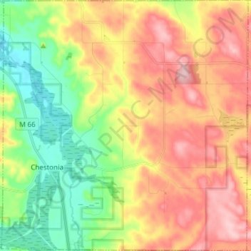
Nom : Carte topographique Jordan Township, altitude, relief.
Lieu : Jordan Township, Antrim County, Michigan, United States (45.03118 -85.10008 45.11835 -84.97858)
Altitude moyenne : 268 m
Altitude minimum : 177 m
Altitude maximum : 367 m
Autres cartes topographiques
Cliquez sur une carte pour visualiser sa topographie, son altitude et son relief.
Central Lake Township
United States > Michigan > Antrim County
Central Lake Township, Antrim County, Michigan, 49622, United States
Altitude moyenne : 226 m
Torch Lake
United States > Michigan > Antrim County
Torch Lake, Torch Lake Township, Antrim County, Michigan, 49627, United States
Altitude moyenne : 180 m
Bellaire
United States > Michigan > Antrim County
Bellaire, Kearney Township, Antrim County, Michigan, 49615, United States
Altitude moyenne : 198 m
Ellsworth
United States > Michigan > Antrim County > Ellsworth
Ellsworth, Banks Township, Antrim County, Michigan, United States
Altitude moyenne : 220 m