
Carte topographique Baile Mòr
Carte interactive
Cliquez sur la carte pour afficher l’altitude.
À propos de cette carte
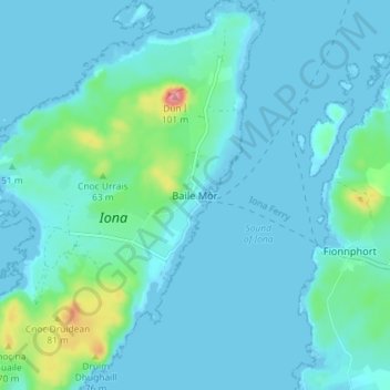
Nom : Carte topographique Baile Mòr, altitude, relief.
Altitude moyenne : 12 m
Altitude minimum : -1 m
Altitude maximum : 96 m
Autres cartes topographiques
Cliquez sur une carte pour visualiser sa topographie, son altitude et son relief.
Island of Danna
Vereinigtes Königreich > Schottland > Argyll and Bute
Island of Danna, Argyll and Bute, Schottland, Vereinigtes Königreich
Altitude moyenne : 9 m
Foreland
Vereinigtes Königreich > Schottland > Argyll and Bute
Foreland, Argyll and Bute, Schottland, PA49 7UU, Vereinigtes Königreich
Altitude moyenne : 32 m
Oban
Vereinigtes Königreich > Schottland > Argyll and Bute
Oban, Argyll and Bute, Schottland, PA34 5PZ, Vereinigtes Königreich
Altitude moyenne : 47 m
Appin
Vereinigtes Königreich > Schottland > Argyll and Bute
Appin, Argyll and Bute, Schottland, PA38 4DB, Vereinigtes Königreich
Altitude moyenne : 93 m
North Connel
Vereinigtes Königreich > Schottland > Argyll and Bute
North Connel, Argyll and Bute, Schottland, PA37 1PL, Vereinigtes Königreich
Altitude moyenne : 19 m
Garelochhead
Vereinigtes Königreich > Schottland > Argyll and Bute
Garelochhead, Argyll and Bute, Schottland, G84 0AY, Vereinigtes Königreich
Altitude moyenne : 110 m