
Carte topographique Ontonagon County
Carte interactive
Cliquez sur la carte pour afficher l’altitude.
À propos de cette carte
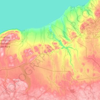
Nom : Carte topographique Ontonagon County, altitude, relief.
Lieu : Ontonagon County, Michigan, United States of America (46.33230 -89.88806 47.03128 -88.86374)
Altitude moyenne : 334 m
Altitude minimum : 174 m
Altitude maximum : 587 m
Autres cartes topographiques
Cliquez sur une carte pour visualiser sa topographie, son altitude et son relief.
Saint Clair County
United States of America > Michigan
Saint Clair County, Michigan, United States of America
Altitude moyenne : 201 m
Oakland County
United States of America > Michigan
Oakland County, Michigan, United States of America
Altitude moyenne : 282 m
Antrim County
United States of America > Michigan
Antrim County, Michigan, United States of America
Altitude moyenne : 276 m
Christmas
United States of America > Michigan > Christmas
Christmas, Au Train Township, Alger County, Michigan, United States of America
Altitude moyenne : 203 m
Brooks Township
United States of America > Michigan
Brooks Township, Newaygo County, Michigan, 49337, United States of America
Altitude moyenne : 237 m
Mena Creek
United States of America > Michigan
Mena Creek, Lincoln Township, Newaygo County, Michigan, 40309, United States of America
Altitude moyenne : 286 m
Sanilac County
United States of America > Michigan
Sanilac County, Michigan, United States of America
Altitude moyenne : 228 m