
Carte topographique Pleasant Hills
Carte interactive
Cliquez sur la carte pour afficher l’altitude.
À propos de cette carte
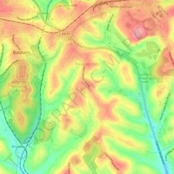
Nom : Carte topographique Pleasant Hills, altitude, relief.
Altitude moyenne : 340 m
Altitude minimum : 276 m
Altitude maximum : 393 m
Autres cartes topographiques
Cliquez sur une carte pour visualiser sa topographie, son altitude et son relief.
Warrendale
United States > Pennsylvania > Allegheny County
Warrendale, Marshall Township, Allegheny County, Pennsylvania, 15086, United States
Altitude moyenne : 359 m
North Braddock
United States > Pennsylvania > Allegheny County
North Braddock, Allegheny County, Pennsylvania, 15104, United States
Altitude moyenne : 282 m
Bellevue
United States > Pennsylvania > Allegheny County
Bellevue, Allegheny County, Pennsylvania, United States
Altitude moyenne : 285 m
Center
United States > Pennsylvania > Allegheny County > Plum
Center, Plum, Allegheny County, Pennsylvania, 15239, United States
Altitude moyenne : 341 m
Clairton
United States > Pennsylvania > Allegheny County > Clairton
Clairton, Allegheny County, Pennsylvania, 15009:15025, United States
Altitude moyenne : 281 m
Pittsburgh
United States > Pennsylvania > Allegheny County
Pittsburgh, Allegheny County, Pennsylvania, United States
Altitude moyenne : 303 m
Elizabeth
United States > Pennsylvania > Allegheny County
Elizabeth, Allegheny County, Pennsylvania, United States
Altitude moyenne : 273 m