
Carte topographique Gwadar
Carte interactive
Cliquez sur la carte pour afficher l’altitude.
À propos de cette carte
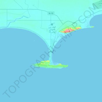
Nom : Carte topographique Gwadar, altitude, relief.
Lieu : Gwadar, ضلع گوادر, Baloutchistan, Pakistan (24.98798 62.16546 25.30798 62.48546)
Altitude moyenne : 6 m
Altitude minimum : -1 m
Altitude maximum : 345 m
Autres cartes topographiques
Cliquez sur une carte pour visualiser sa topographie, son altitude et son relief.
خضدار
خضدار, District de Khuzdar, Baloutchistan, 89100, Pakistan
Altitude moyenne : 1 417 m
Lasbela District
Lasbela District, ضلع لسبیلہ, Baloutchistan, Pakistan
Altitude moyenne : 245 m
تفتان
Pakistan > Baloutchistan > تفتان
تفتان, ضلع چاغی, Baloutchistan, Pakistan
Altitude moyenne : 812 m
Zhob
Pakistan > Baloutchistan > Zhob
Zhob, Zhob District, Baloutchistan, 85200, Pakistan
Altitude moyenne : 1 568 m
Kech
Pakistan > Baloutchistan > Turbat
Kech, Turbat, ضلع گوادر / Kech, Baloutchistan, 92600, Pakistan
Altitude moyenne : 561 m