
Carte topographique Garath
Carte interactive
Cliquez sur la carte pour afficher l’altitude.
À propos de cette carte
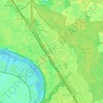
Nom : Carte topographique Garath, altitude, relief.
Altitude moyenne : 44 m
Altitude minimum : 33 m
Altitude maximum : 50 m
Autres cartes topographiques
Cliquez sur une carte pour visualiser sa topographie, son altitude et son relief.
Schloss Benrath
Deutschland > Nordrhein-Westfalen > Benrath
Schloss Benrath, 104, Benrather Schloßallee, Benrath, Stadtbezirk 9, Benrath, Düsseldorf, Regierungsbezirk Düsseldorf, Nordrhein-Westfalen, 40597, Deutschland
Altitude moyenne : 44 m