
Carte topographique Arak
Carte interactive
Cliquez sur la carte pour afficher l’altitude.
À propos de cette carte
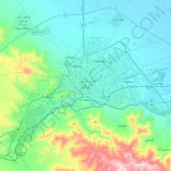
Nom : Carte topographique Arak, altitude, relief.
Lieu : Arak, بخش مرکزی, Arak County, Markazi Province, Iran (34.04294 49.60821 34.13117 49.79708)
Altitude moyenne : 1 871 m
Altitude minimum : 1 669 m
Altitude maximum : 2 616 m
Arak is surrounded by mountains in the south, west, and east, and its average altitude is about 1750m above sea level. It is located 260 km from the city of Tehran, and is in the vicinity of the cities of Qom and Isfahan.