
Faire un don
Équipez-vous pour votre prochaine aventure :
En tant que Partenaire Amazon, ce site perçoit une commission sur les achats éligibles sans surcoût pour vous.
Carte topographique Eastvale
Cliquez sur la carte pour afficher l’altitude.
Faire un don
Équipez-vous pour votre prochaine aventure :
En tant que Partenaire Amazon, ce site perçoit une commission sur les achats éligibles sans surcoût pour vous.
À propos de cette carte
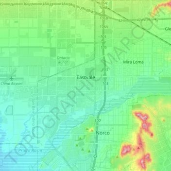
Nom : Carte topographique Eastvale, altitude, relief.
Lieu : Eastvale, Riverside County, California, United States (33.90323 -117.61549 34.03348 -117.54883)
Altitude moyenne : 214 m
Altitude minimum : 146 m
Altitude maximum : 455 m
Faire un don
Équipez-vous pour votre prochaine aventure :
En tant que Partenaire Amazon, ce site perçoit une commission sur les achats éligibles sans surcoût pour vous.
Autres cartes topographiques
Cliquez sur une carte pour visualiser sa topographie, son altitude et son relief.
Colorado River
United States > California > Riverside County
The entire eastern boundary of the Colorado River Basin runs along the North American Continental Divide and is defined largely by the Rocky Mountains and the Rio Grande Basin. The Wind River Range in Wyoming marks the northern extent of the basin, and is separated from the Colorado Rockies by the endorheic…
Altitude moyenne : 93 m
Idyllwild-Pine Cove
United States > California > Riverside County
"Mile-high Idyllwild" is a mountain resort about one-mile (1,600 m) in altitude. Idyllwild is flanked by two large rock formations, Tahquitz Peak and Suicide Rock (also known as Lily Rock), which are famous in Southern California rock-climbing circles. It offers no skiing, so "the Hill" has been minimally…
Altitude moyenne : 1 746 m
Faire un don
Équipez-vous pour votre prochaine aventure :
En tant que Partenaire Amazon, ce site perçoit une commission sur les achats éligibles sans surcoût pour vous.