
Carte topographique Waterville
Carte interactive
Cliquez sur la carte pour afficher l’altitude.
À propos de cette carte
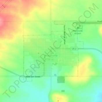
Nom : Carte topographique Waterville, altitude, relief.
Altitude moyenne : 807 m
Altitude minimum : 769 m
Altitude maximum : 856 m
At 2,625 ft (800 m), Waterville has the highest elevation of any incorporated city or town in Washington.
Autres cartes topographiques
Cliquez sur une carte pour visualiser sa topographie, son altitude et son relief.
Palisades
United States > Washington > Douglas County
Palisades, Douglas County, Washington, 98845, United States
Altitude moyenne : 482 m
Bridgeport
United States > Washington > Douglas County
Bridgeport, Douglas County, Washington, 98813, United States
Altitude moyenne : 313 m
Orondo
United States > Washington > Douglas County
Orondo, Douglas County, Washington, United States
Altitude moyenne : 386 m
Mansfield
United States > Washington > Douglas County
Mansfield, Douglas County, Washington, United States
Altitude moyenne : 690 m
Rock Island
United States > Washington > Douglas County
Rock Island, Douglas County, Washington, 98850, United States
Altitude moyenne : 214 m
East Wenatchee Bench
United States > Washington > Douglas County > East Wenatchee
East Wenatchee Bench, East Wenatchee, Douglas County, Washington, 98802, United States
Altitude moyenne : 296 m
Sunny Beach
United States > Washington > Douglas County
Sunny Beach, Douglas County, Washington, United States
Altitude moyenne : 220 m
Moses Coulee
United States > Washington > Douglas County
Moses Coulee, Douglas County, Washington, 98845, United States
Altitude moyenne : 665 m
East Wenatchee
United States > Washington > Douglas County
East Wenatchee, Douglas County, Washington, 98802, United States
Altitude moyenne : 249 m