
Carte topographique Vanderbijlpark
Carte interactive
Cliquez sur la carte pour afficher l’altitude.
À propos de cette carte
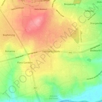
Nom : Carte topographique Vanderbijlpark, altitude, relief.
Altitude moyenne : 1 474 m
Altitude minimum : 1 421 m
Altitude maximum : 1 525 m
Vanderbijlpark is situated on the highveld of South Africa, at an altitude of 1,500 meters on the banks of the Vaal River. Summers in the city are warm to hot with an average high between 31 and 35°C, and an average low between 15 and 22°C. Winters in the city are cool to warm with an average high of between 18 and 23°C and an average low of between −1 and 5°C.
Autres cartes topographiques
Cliquez sur une carte pour visualiser sa topographie, son altitude et son relief.
Evaton
South Africa > Gauteng > Sedibeng District Municipality > Emfuleni Local Municipality
Evaton, Emfuleni Local Municipality, Sedibeng District Municipality, Gauteng, South Africa
Altitude moyenne : 1 522 m
Sebokeng
South Africa > Gauteng > Sedibeng District Municipality > Emfuleni Local Municipality
Sebokeng, Emfuleni Local Municipality, Sedibeng District Municipality, Gauteng, 1984, South Africa
Altitude moyenne : 1 523 m