
Carte topographique Redfish Lake
Carte interactive
Cliquez sur la carte pour afficher l’altitude.
Redfish Lake
The surface elevation of Redfish Lake is 6,547 feet (1,996 m) above sea level. The lake is 4.5 miles (7.2 km) long and 0.72 miles (1.2 km) wide, with a maximum depth of 387 feet (118 m), and 11 miles (18 km) of shoreline. The actual trail around the lake is 17.5 miles (28 km) in length.
À propos de cette carte
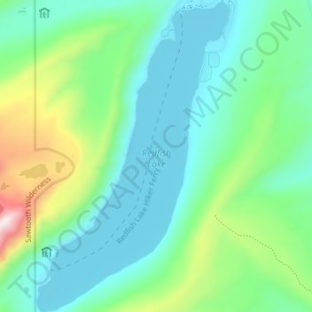
Nom : Carte topographique Redfish Lake, altitude, relief.
Lieu : Redfish Lake, Custer County, Idaho, United States (44.09323 -114.95587 44.14436 -114.91176)
Altitude moyenne : 2 144 m
Altitude minimum : 1 989 m
Altitude maximum : 2 637 m
Autres cartes topographiques
Cliquez sur une carte pour visualiser sa topographie, son altitude et son relief.
Stanley
United States > Idaho > Custer County
Stanley is located at 44°13′0″N 114°56′16″W / 44.21667°N 114.93778°W / 44.21667; -114.93778 (44.216698, -114.937814), at an elevation of 6,253 feet (1,906 m) above sea level
Altitude moyenne : 1 931 m
Mackay
United States > Idaho > Custer County
Mackay is located at 43°54′43″N 113°36′49″W / 43.91194°N 113.61361°W / 43.91194; -113.61361 (43.911880, -113.613669), at an elevation of 5,905 feet (1,800 m).
Altitude moyenne : 1 811 m
Challis
United States > Idaho > Custer County
Challis is located at 44°30′15″N 114°13′42″W / 44.50417°N 114.22833°W / 44.50417; -114.22833 (44.504260, -114.228279), at an elevation of 5,253 feet (1,601 m) above sea level.
Altitude moyenne : 1 626 m