
Carte topographique Ban Chang
Carte interactive
Cliquez sur la carte pour afficher l’altitude.
À propos de cette carte
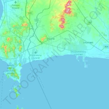
Nom : Carte topographique Ban Chang, altitude, relief.
Lieu : Ban Chang, Rayong Province, 21130, Thailand (12.51857 100.90714 12.83857 101.22714)
Altitude moyenne : 32 m
Altitude minimum : -3 m
Altitude maximum : 406 m
Autres cartes topographiques
Cliquez sur une carte pour visualiser sa topographie, son altitude et son relief.
Map Ta Phut
Map Ta Phut, Thap Ma, Rayong Province, 21150, Thailand
Altitude moyenne : 24 m
Rayong
Rayong, Choeng Noen, Rayong Province, 21000, Thailand
Altitude moyenne : 31 m