
Carte topographique Cookley
Cliquez sur la carte pour afficher l’altitude.
À propos de cette carte
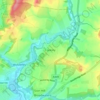
Nom : Carte topographique Cookley, altitude, relief.
Altitude moyenne : 70 m
Altitude minimum : 35 m
Altitude maximum : 137 m
Autres cartes topographiques
Cliquez sur une carte pour visualiser sa topographie, son altitude et son relief.
Kidderminster
United Kingdom > England > Worcestershire > Wyre Forest > Larkhill
Altitude moyenne : 56 m
Stourport Historic Canal Basins
United Kingdom > England > Worcestershire > Wyre Forest > Stourport-on-Severn > Wilden
Altitude moyenne : 33 m
River Severn
United Kingdom > England > Worcestershire > Wyre Forest > Stourport-on-Severn
Altitude moyenne : 45 m