
Carte topographique العاشر من رمضان
Carte interactive
Cliquez sur la carte pour afficher l’altitude.
À propos de cette carte
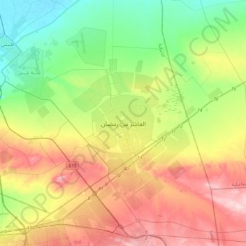
Nom : Carte topographique العاشر من رمضان, altitude, relief.
Lieu : العاشر من رمضان, Est, 44629, Égypte (30.15545 31.57928 30.47545 31.89928)
Altitude moyenne : 104 m
Altitude minimum : 8 m
Altitude maximum : 247 m
Autres cartes topographiques
Cliquez sur une carte pour visualiser sa topographie, son altitude et son relief.
قريه اولاد العدوى
Égypte > Est > قريه اولاد العدوى
قريه اولاد العدوى, Est, 47713, Égypte
Altitude moyenne : 7 m