
Carte topographique Black Canyon City
Carte interactive
Cliquez sur la carte pour afficher l’altitude.
À propos de cette carte
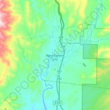
Nom : Carte topographique Black Canyon City, altitude, relief.
Altitude moyenne : 763 m
Altitude minimum : 549 m
Altitude maximum : 1 464 m
Black Canyon City is located at 34°4′11″N 112°8′22″W / 34.06972°N 112.13944°W / 34.06972; -112.13944 (34.069719, -112.139466), at an elevation of 1,975 feet (602 m).
Autres cartes topographiques
Cliquez sur une carte pour visualiser sa topographie, son altitude et son relief.
Prescott
United States > Arizona > Yavapai County
Prescott, Yavapai County, Arizona, United States
Altitude moyenne : 1 674 m
Chino Valley
United States > Arizona > Yavapai County
Chino Valley, Yavapai County, Arizona, 86323, United States
Altitude moyenne : 1 454 m
Ash Fork
United States > Arizona > Yavapai County > Ash Fork
Ash Fork, Yavapai County, Arizona, 86320, United States
Altitude moyenne : 1 561 m
Cottonwood
United States > Arizona > Yavapai County
Cottonwood, Yavapai County, Arizona, United States
Altitude moyenne : 1 118 m
Prescott Valley
United States > Arizona > Yavapai County
Prescott Valley, Yavapai County, Arizona, United States
Altitude moyenne : 1 550 m
Sedona
United States > Arizona > Yavapai County
Sedona, Yavapai County, Arizona, 86336, United States
Altitude moyenne : 1 342 m