
Carte topographique Tutaekuri River
Carte interactive
Cliquez sur la carte pour afficher l’altitude.
À propos de cette carte
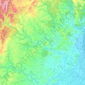
Nom : Carte topographique Tutaekuri River, altitude, relief.
Altitude moyenne : 252 m
Altitude minimum : -1 m
Altitude maximum : 1 215 m
Autres cartes topographiques
Cliquez sur une carte pour visualiser sa topographie, son altitude et son relief.
Te Mata Peak
Te Mata Peak, Hastings, Hastings District, Hawke's Bay, 4130, New Zealand
Altitude moyenne : 144 m
Te Mata Peak
Te Mata Peak, Hastings, Hastings District, Hawke's Bay, 4294, New Zealand
Altitude moyenne : 145 m
Lake Opouahi
Lake Opouahi, Pohokura Road, Hastings, Hastings District, Hawke's Bay, New Zealand
Altitude moyenne : 477 m
Raupare Stream
Raupare Stream, Hastings, Hastings District, Hawke's Bay, 4122, New Zealand
Altitude moyenne : 8 m
Clive River
Clive River, Hastings, Hastings District, Hawke's Bay, 4102, New Zealand
Altitude moyenne : 5 m