
Carte topographique Alpine
Carte interactive
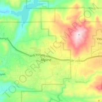
Cliquez sur la carte pour afficher l’altitude.
À propos de cette carte
Nom : Carte topographique Alpine, altitude, relief.
Altitude moyenne : 581 m
Altitude minimum : 170 m
Altitude maximum : 1 272 m
Alpine sits on both sides of Interstate 8 at the eastern extent of the California coastal region and the western extent of the Peninsular Ranges, about 30 miles (48 km) east of downtown San Diego, at an elevation of about 2,000 feet (610 m).
Autres cartes topographiques
Cliquez sur une carte pour visualiser sa topographie, son altitude et son relief.
Coronado
United States > California > San Diego County
Coronado, San Diego County, California, United States
Altitude moyenne : 5 m
San Diego
United States > California > San Diego County
San Diego, San Diego County, California, United States
Altitude moyenne : 125 m
Oceanside
United States > California > San Diego County
Oceanside, San Diego County, CAL Fire Southern Region, California, United States
Altitude moyenne : 33 m
Encinitas
United States > California > San Diego County
Encinitas, San Diego County, California, United States
Altitude moyenne : 32 m
Oak Park
United States > California > San Diego County > San Diego
Oak Park, San Diego, San Diego County, California, 92105, United States
Altitude moyenne : 108 m
Del Mar
United States > California > San Diego County > Del Mar
Del Mar, San Diego County, California, United States
Altitude moyenne : 24 m
Escondido
United States > California > San Diego County
Escondido, San Diego County, California, United States
Altitude moyenne : 273 m
Lemon Grove
United States > California > San Diego County
Lemon Grove, San Diego County, CAL Fire Southern Region, California, 91945, United States
Altitude moyenne : 129 m