Carte topographique Alderley Edge
Carte interactive
Cliquez sur la carte pour afficher l’altitude.
À propos de cette carte
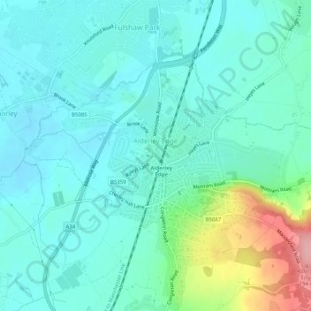
Nom : Carte topographique Alderley Edge, altitude, relief.
Lieu : Alderley Edge, Cheshire East, England, United Kingdom (53.29448 -2.25853 53.31426 -2.20820)
Altitude moyenne : 91 m
Altitude minimum : 63 m
Altitude maximum : 194 m
Alderley Edge is 6 miles (10 km) northwest of Macclesfield and 12 miles (19 km) south of Manchester, at the base of a steep and thickly wooded sandstone escarpment, Alderley Edge, which is the area's chief topographical feature and overlooks the Cheshire Plain.
Autres cartes topographiques
Cliquez sur une carte pour visualiser sa topographie, son altitude et son relief.
Winterley
United Kingdom > England > Cheshire East
Winterley, Cheshire East, England, CW11 4RS, United Kingdom
Altitude moyenne : 62 m
Wood Lanes
United Kingdom > England > Cheshire East > Poynton
Wood Lanes, Adlington, Poynton, Cheshire East, England, SK10 4PE, United Kingdom
Altitude moyenne : 162 m
Dean Row
United Kingdom > England > Cheshire East > Wilmslow
Dean Row, Wilmslow, Cheshire East, England, SK9 2BN, United Kingdom
Altitude moyenne : 83 m
Arclid
United Kingdom > England > Cheshire East
Arclid, Cheshire East, England, United Kingdom
Altitude moyenne : 75 m
Lyme Park
United Kingdom > England > Cheshire East > Disley
Lyme Park, Disley, Cheshire East, England, United Kingdom
Altitude moyenne : 260 m
Peckforton Moss
United Kingdom > England > Cheshire East > Bulkeley > Peckforton
Peckforton Moss, Peckforton, Bulkeley, Cheshire East, England, United Kingdom
Altitude moyenne : 100 m
Cholmondeley
United Kingdom > England > Cheshire East
Cholmondeley, Cheshire East, England, United Kingdom
Altitude moyenne : 94 m
Oakgrove
United Kingdom > England > Cheshire East
Oakgrove, Cheshire East, England, SK11 0JF, United Kingdom
Altitude moyenne : 200 m
Peover Heath
United Kingdom > England > Cheshire East > Over Peover
Peover Heath, Peover Superior and Snelson, Over Peover, Cheshire East, England, WA16 8UP, United Kingdom
Altitude moyenne : 73 m
Crewe Green
United Kingdom > England > Cheshire East
Crewe Green, Cheshire East, England, CW1 5UN, United Kingdom
Altitude moyenne : 58 m
Macclesfield
United Kingdom > England > Cheshire East
Macclesfield, Cheshire East, England, United Kingdom
Altitude moyenne : 182 m
Poynton
United Kingdom > England > Cheshire East
Poynton, Cheshire East, England, SK12 1GP, United Kingdom
Altitude moyenne : 130 m
Marbury
United Kingdom > England > Cheshire East
Marbury, Cheshire East, England, SY13 4LS, United Kingdom
Altitude moyenne : 92 m
Broomhall
United Kingdom > England > Cheshire East
Broomhall, Cheshire East, England, United Kingdom
Altitude moyenne : 60 m
Capesthorne
United Kingdom > England > Cheshire East > Siddington
Capesthorne, Siddington, Cheshire East, England, SK11 9LB, United Kingdom
Altitude moyenne : 93 m
Wilmslow
United Kingdom > England > Cheshire East
Wilmslow, Cheshire East, England, SK9 1DS, United Kingdom
Altitude moyenne : 84 m
Checkley
United Kingdom > England > Cheshire East
Checkley, Checkley cum Wrinehill, Cheshire East, England, CW5 7QA, United Kingdom
Altitude moyenne : 85 m
Chelford
United Kingdom > England > Cheshire East
Chelford, Cheshire East, England, United Kingdom
Altitude moyenne : 78 m
Scholar Green
United Kingdom > England > Cheshire East
Scholar Green, Cheshire East, England, ST7 3HH, United Kingdom
Altitude moyenne : 124 m
Crewe
United Kingdom > England > Cheshire East
Crewe, Cheshire East, England, United Kingdom
Altitude moyenne : 52 m
Macclesfield Canal
United Kingdom > England > Cheshire East > Stockport
Macclesfield Canal, Stockport, Cheshire East, Greater Manchester, England, SK10 4GX, United Kingdom
Altitude moyenne : 191 m
Calveley
United Kingdom > England > Cheshire East
Calveley, Cheshire East, England, United Kingdom
Altitude moyenne : 51 m
Haslington
United Kingdom > England > Cheshire East
Haslington, Cheshire East, England, United Kingdom
Altitude moyenne : 64 m
Disley
United Kingdom > England > Cheshire East
Disley, Cheshire East, England, United Kingdom
Altitude moyenne : 229 m
Ridgegate Reservoir
United Kingdom > England > Cheshire East > Langley
Ridgegate Reservoir, Sutton, Langley, Cheshire East, England, United Kingdom
Altitude moyenne : 289 m
Styal
United Kingdom > England > Cheshire East
Styal, Cheshire East, England, United Kingdom
Altitude moyenne : 76 m
Nantwich
United Kingdom > England > Cheshire East
Nantwich, Cheshire East, England, United Kingdom
Altitude moyenne : 45 m
Higher Poynton
United Kingdom > England > Cheshire East > Poynton > Higher Poynton
Higher Poynton, Poynton-with-Worth, Poynton, Cheshire East, England, SK12 1TJ, United Kingdom
Altitude moyenne : 157 m
Somerford
United Kingdom > England > Cheshire East
Somerford, Cheshire East, England, United Kingdom
Altitude moyenne : 82 m
Hulme Walfield
United Kingdom > England > Cheshire East > Hulme Walfield
Hulme Walfield, Cheshire East, England, United Kingdom
Altitude moyenne : 99 m
Wilmslow
United Kingdom > England > Cheshire East
Wilmslow, Cheshire East, England, United Kingdom
Altitude moyenne : 81 m
Bickerton
United Kingdom > England > Cheshire East
Bickerton, Cheshire East, England, United Kingdom
Altitude moyenne : 128 m
Kettleshulme
United Kingdom > England > Cheshire East > Kettleshulme
Kettleshulme, Cheshire East, North West England, England, United Kingdom
Altitude moyenne : 311 m
Walgherton
United Kingdom > England > Cheshire East > Wybunbury > Walgherton
Walgherton, Wybunbury, Cheshire East, North West England, England, United Kingdom
Altitude moyenne : 63 m
Chorley
United Kingdom > England > Cheshire East > Chorley
Chorley, Cheshire East, North West England, England, United Kingdom
Altitude moyenne : 73 m
Burleydam
United Kingdom > England > Cheshire East > Burleydam
Burleydam, Dodcott cum Wilkesley, Cheshire East, North West England, England, SY13 4AT, United Kingdom
Altitude moyenne : 79 m
Knutsford
United Kingdom > England > Cheshire East
Knutsford, Cheshire East, England, United Kingdom
Altitude moyenne : 57 m
Weston
United Kingdom > England > Cheshire East
Weston, Cheshire East, North West England, England, United Kingdom
Altitude moyenne : 69 m
Ollerton
United Kingdom > England > Cheshire East
Ollerton, Cheshire East, England, United Kingdom
Altitude moyenne : 66 m
Gawsworth
United Kingdom > England > Cheshire East
Gawsworth, Cheshire East, North West England, England, United Kingdom
Altitude moyenne : 145 m
Goostrey
United Kingdom > England > Cheshire East
Goostrey, Cheshire East, England, United Kingdom
Altitude moyenne : 67 m
Tabley
United Kingdom > England > Cheshire East > Over Tabley > Tabley
Tabley, Tabley Superior, Over Tabley, Cheshire East, North West England, England, WA16 0WN, United Kingdom
Altitude moyenne : 51 m
Wistaston
United Kingdom > England > Cheshire East
Wistaston, Cheshire East, North West England, England, United Kingdom
Altitude moyenne : 46 m
Over Alderley
United Kingdom > England > Cheshire East
Over Alderley, Cheshire East, North West England, England, United Kingdom
Altitude moyenne : 142 m
Whirley Grove
United Kingdom > England > Cheshire East > Macclesfield > Whirley Grove
Whirley Grove, Macclesfield, Cheshire East, North West England, England, SK10 4RJ, United Kingdom
Altitude moyenne : 154 m
Bosley
United Kingdom > England > Cheshire East
Bosley, Cheshire East, North West England, England, United Kingdom
Altitude moyenne : 208 m
Adlington
United Kingdom > England > Cheshire East
Adlington, Cheshire East, England, United Kingdom
Altitude moyenne : 124 m
Sandbach
United Kingdom > England > Cheshire East
Sandbach, Cheshire East, England, United Kingdom
Altitude moyenne : 64 m
Bollington
United Kingdom > England > Cheshire East
Bollington, Cheshire East, England, United Kingdom
Altitude moyenne : 163 m
Middlewich
United Kingdom > England > Cheshire East
Middlewich, Cheshire East, England, United Kingdom
Altitude moyenne : 40 m