
Carte topographique Medel (Lucmagn)
Carte interactive
Cliquez sur la carte pour afficher l’altitude.
À propos de cette carte
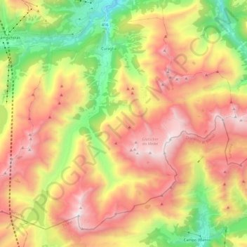
Nom : Carte topographique Medel (Lucmagn), altitude, relief.
Lieu : Medel (Lucmagn), Surselva, Grisons, Switzerland (46.56313 8.75041 46.69194 8.96910)
Altitude moyenne : 2 100 m
Altitude minimum : 1 041 m
Altitude maximum : 3 179 m
Before 2017, the municipality was located in the Disentis sub-district of the Surselva district, after 2017 it was part of the Surselva Region. It is located in the Medelserrhein river basin. It includes the 16 km (9.9 mi) long Medel Valley, which connects Upper Graubünden with the canton of Ticino. It consists of a number of settlements at an elevation of 1,332–1,621 meters (4,370–5,318 ft). These include: Curaglia (main village), Soliva, Mutschnengia, Platta, Drual/Matergia, Pardé, Fuorns and S. Gions. The municipality also includes about 50 abandoned farm houses and summer herding camps, including Pali, Biscuolm and Casura. Until 1943 Medel (Lucmagn) was known as Medels im Oberland.
Autres cartes topographiques
Cliquez sur une carte pour visualiser sa topographie, son altitude et son relief.
Breil/Brigels
Switzerland > Grisons > Surselva
Breil/Brigels, Surselva, Grisons, Switzerland
Altitude moyenne : 1 885 m
Lake Toma
Switzerland > Grisons > Surselva > Tujetsch
Lake Toma, Tujetsch, Surselva, Grisons, Switzerland
Altitude moyenne : 2 390 m
Vals
Switzerland > Grisons > Surselva
Vals, Surselva, Grisons, 7132, Switzerland
Altitude moyenne : 2 177 m
Soladüra
Switzerland > Grisons > Surselva > Vals
Soladüra, Vals, Surselva, Grisons, 7132, Switzerland
Altitude moyenne : 1 806 m
Tujetsch
Switzerland > Grisons > Surselva
Tujetsch, Surselva, Grisons, Switzerland
Altitude moyenne : 2 147 m