
Carte topographique Kampung Pantai
Carte interactive
Cliquez sur la carte pour afficher l’altitude.
À propos de cette carte
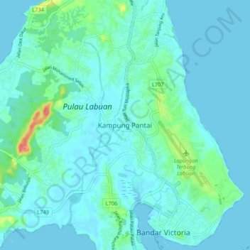
Nom : Carte topographique Kampung Pantai, altitude, relief.
Lieu : Kampung Pantai, Labuan, 87000, Malaysia (5.27137 115.19100 5.35137 115.27100)
Altitude moyenne : 10 m
Altitude minimum : 0 m
Altitude maximum : 70 m
Autres cartes topographiques
Cliquez sur une carte pour visualiser sa topographie, son altitude et son relief.
Daat Island
Malaysia > Labuan > Labuan > Victoria
Daat Island, Victoria, Labuan, Malaysia
Altitude moyenne : 5 m
Taman Awam Pantai Tanjung Purun
Malaysia > Labuan > Labuan > Victoria
Taman Awam Pantai Tanjung Purun, Victoria, Labuan, Malaysia
Altitude moyenne : 4 m
Labuan Bird Park
Malaysia > Labuan > Kampung Pohon Batu
Labuan Bird Park, Kampung Pohon Batu, Labuan, 87000, Malaysia
Altitude moyenne : 13 m
Kampung Patau-Patau II (Water Village)
Kampung Patau-Patau II (Water Village), Victoria, Labuan, 87009, Malaysia
Altitude moyenne : 7 m