
Carte topographique El Durazno
Carte interactive
Cliquez sur la carte pour afficher l’altitude.
À propos de cette carte
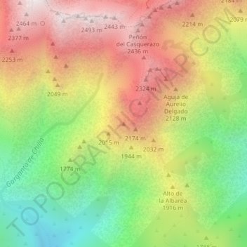
Nom : Carte topographique El Durazno, altitude, relief.
Lieu : El Durazno, Candeleda, Ávila, Castile and León, Spain (40.23098 -5.28534 40.23108 -5.28524)
Altitude moyenne : 1 839 m
Altitude minimum : 1 183 m
Altitude maximum : 2 497 m
Autres cartes topographiques
Cliquez sur une carte pour visualiser sa topographie, son altitude et son relief.
Juan González
Spain > Castile and León > Candeleda
Juan González, Candeleda, Ávila, Castile and León, 05480, Spain
Altitude moyenne : 1 104 m