
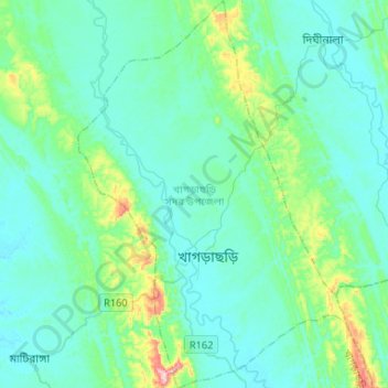
Carte topographique Khagrachari
Carte interactive
Cliquez sur la carte pour afficher l’altitude.
À propos de cette carte
Nom : Carte topographique Khagrachari, altitude, relief.
Altitude moyenne : 87 m
Altitude minimum : 32 m
Altitude maximum : 405 m
Autres cartes topographiques
Cliquez sur une carte pour visualiser sa topographie, son altitude et son relief.
Cox's Bazar
Bangladesh > Chattogram Division
Cox's Bazar, Cox's Bazar District, Chattogram Division, 4700, Bangladesh
Altitude moyenne : 13 m
Chattogram
Bangladesh > Chattogram Division > Chattogram
Chattogram, Chattogram District, Chattogram Division, 4000, Bangladesh
Altitude moyenne : 6 m
Chiringa
Bangladesh > Chattogram Division
Chiringa, Cox's Bazar District, Chattogram Division, 4740, Bangladesh
Altitude moyenne : 4 m
Rowangchhari Upazila
Bangladesh > Chattogram Division
Rowangchhari Upazila, Bandarban Hill District, Chattogram Division, Bangladesh
Altitude moyenne : 215 m
Khidirpur
Bangladesh > Chattogram Division > Matlab Dakshin Upazila
Khidirpur, Matlab Dakshin Upazila, Chandpur District, Chattogram Division, Bangladesh
Altitude moyenne : 6 m
Lama
Bangladesh > Chattogram Division
Lama, Bandarban Hill District, Chattogram Division, Bangladesh
Altitude moyenne : 59 m
Fatikchhari Upazila
Bangladesh > Chattogram Division
Fatikchhari Upazila, Chattogram District, Chattogram Division, Bangladesh
Altitude moyenne : 30 m
Gachhtola
Bangladesh > Chattogram Division > Chandpur Sadar Upazila
Gachhtola, Chandpur Sadar Upazila, Chandpur District, Chattogram Division, 3600, Bangladesh
Altitude moyenne : 8 m
Rohingya Refugee Camp in Bangladesh
Bangladesh > Chattogram Division
Rohingya Refugee Camp in Bangladesh, Cox's Bazar District, Chattogram Division, Bangladesh
Altitude moyenne : 14 m
Bandarban Hill District
Bangladesh > Chattogram Division
Bandarban Hill District, Chattogram Division, Bangladesh
Altitude moyenne : 190 m
Jaliapalong
Bangladesh > Chattogram Division
Jaliapalong, Cox's Bazar District, Chattogram Division, Bangladesh
Altitude moyenne : 17 m
Kaptai Dam
Bangladesh > Chattogram Division > Kaptai Upazila > Kaptai
Kaptai Dam, Kaptai, Kaptai Upazila, Rangamati Hill District, Chattogram Division, Bangladesh
Altitude moyenne : 32 m
Kaptai Upazila
Bangladesh > Chattogram Division
Kaptai Upazila, Rangamati Hill District, Chattogram Division, 4532, Bangladesh
Altitude moyenne : 65 m
Rangunia
Bangladesh > Chattogram Division
Rangunia, Chattogram District, Chattogram Division, Bangladesh
Altitude moyenne : 11 m
Sitakunda
Bangladesh > Chattogram Division > Sitakunda Upazila > Sitakunda
Sitakunda, Sitakunda Upazila, Chattogram District, Chattogram Division, Bangladesh
Altitude moyenne : 11 m
Chattogram District
Bangladesh > Chattogram Division
Chattogram District, Chattogram Division, Bangladesh
Altitude moyenne : 28 m
Feni
Bangladesh > Chattogram Division > Feni Sadar Upazila
Feni, Feni Sadar Upazila, Feni District, Chattogram Division, 3900, Bangladesh
Altitude moyenne : 11 m
Kaptai National Park,Kaptai, Rangamati.
Bangladesh > Chattogram Division > Rajasthali Upazila
Kaptai National Park,Kaptai, Rangamati., Rajasthali Upazila, Rangamati Hill District, Chattogram Division, 4533, Bangladesh
Altitude moyenne : 85 m
Kutupalong
Bangladesh > Chattogram Division
Kutupalong, Cox's Bazar District, Chattogram Division, Bangladesh
Altitude moyenne : 15 m
Saint Martin
Bangladesh > Chattogram Division
Saint Martin, Cox's Bazar District, Chattogram Division, Bangladesh
Altitude moyenne : 0 m
Rangamati Hill District
Bangladesh > Chattogram Division
Rangamati Hill District, Chattogram Division, Bangladesh
Altitude moyenne : 276 m
Hathazari Upazila
Bangladesh > Chattogram Division
Hathazari Upazila, Chattogram District, Chattogram Division, Bangladesh
Altitude moyenne : 18 m
Bojoypur
Bangladesh > Chattogram Division > Cumilla Adarsha Sadar Upazila
Bojoypur, Cumilla Adarsha Sadar Upazila, Cumilla District, Chattogram Division, Bangladesh
Altitude moyenne : 11 m
Boalkhali
Bangladesh > Chattogram Division
Boalkhali, Chattogram District, Chattogram Division, Bangladesh
Altitude moyenne : 4 m
Lakshmipur
Bangladesh > Chattogram Division > Lakshmipur Sadar Upazila
Lakshmipur, Lakshmipur Sadar Upazila, Lakshmipur District, Chattogram Division, 3700, Bangladesh
Altitude moyenne : 6 m
Alikadam
Bangladesh > Chattogram Division
Alikadam, Bandarban Hill District, Chattogram Division, Bangladesh
Altitude moyenne : 207 m
Camp 21
Bangladesh > Chattogram Division > Rohingya Refugee Camp in Bangladesh
Camp 21, Rohingya Refugee Camp in Bangladesh, Cox's Bazar District, Chattogram Division, Bangladesh
Altitude moyenne : 15 m
Sonaimuri
Bangladesh > Chattogram Division
Sonaimuri, Noakhali District, Chattogram Division, Bangladesh
Altitude moyenne : 7 m
Kutubpur
Bangladesh > Chattogram Division
Kutubpur, Noakhali District, Chattogram Division, Bangladesh
Altitude moyenne : 7 m
Sonaimuri
Bangladesh > Chattogram Division > Hajiganj Upazila
Sonaimuri, Hajiganj Upazila, Chandpur District, Chattogram Division, Bangladesh
Altitude moyenne : 6 m
Sitakunda
Bangladesh > Chattogram Division > Sitakunda Upazila
Sitakunda, Sitakunda Upazila, Chattogram District, Chattogram Division, Bangladesh
Altitude moyenne : 40 m
Chhota Lakshmipur
Bangladesh > Chattogram Division > Matlab Uttar Upazila
Chhota Lakshmipur, Matlab Uttar Upazila, Chandpur District, Chattogram Division, 3640, Bangladesh
Altitude moyenne : 5 m
Nalua
Bangladesh > Chattogram Division > Kachua Upazila
Nalua, Kachua Upazila, Chandpur District, Chattogram Division, 3508, Bangladesh
Altitude moyenne : 7 m
Cox's Bazar District
Bangladesh > Chattogram Division
Cox's Bazar District, Chattogram Division, Bangladesh
Altitude moyenne : 60 m
Cumilla
Bangladesh > Chattogram Division > Cumilla Adarsha Sadar Upazila
Cumilla, Cumilla Adarsha Sadar Upazila, Cumilla District, Chattogram Division, 3502, Bangladesh
Altitude moyenne : 16 m
Raipur (Lakshmipur)
Bangladesh > Chattogram Division
Raipur (Lakshmipur), Lakshmipur District, Chattogram Division, 3710, Bangladesh
Altitude moyenne : 4 m
Rangamati
Bangladesh > Chattogram Division
Rangamati, Rangamati Hill District, Chattogram Division, 0351, Bangladesh
Altitude moyenne : 71 m
Bandarban
Bangladesh > Chattogram Division > Bandarban
Bandarban, Bandarban District, Chattogram Division, Bangladesh
Altitude moyenne : 67 m
Chandpur Sadar Upazila
Bangladesh > Chattogram Division
Chandpur Sadar Upazila, Chandpur District, Chattogram Division, Bangladesh
Altitude moyenne : 5 m
Chattogram
Bangladesh > Chattogram Division
Chattogram, Chattogram District, Chattogram Division, 4000, Bangladesh
Altitude moyenne : 6 m
Kachhapia
Bangladesh > Chattogram Division
Kachhapia, Cox's Bazar District, Chattogram Division, Bangladesh
Altitude moyenne : 18 m
Sandwip
Bangladesh > Chattogram Division
Sandwip, Chattogram District, Chattogram Division, Bangladesh
Altitude moyenne : 2 m
Ukhia
Bangladesh > Chattogram Division
Ukhia, Cox's Bazar District, Chattogram Division, 4750, Bangladesh
Altitude moyenne : 18 m
Bandarban
Bangladesh > Chattogram Division
Bandarban, Bandarban Hill District, Chattogram Division, Bangladesh
Altitude moyenne : 78 m
Moheshkhali
Bangladesh > Chattogram Division
Moheshkhali, Cox's Bazar District, Chattogram Division, Bangladesh
Altitude moyenne : 8 m
Ramgati
Bangladesh > Chattogram Division
Ramgati, Lakshmipur District, Chattogram Division, Bangladesh
Altitude moyenne : 3 m
Kaptai
Bangladesh > Chattogram Division > Chandraghona
Kaptai, Chandraghona, Rangamati Hill District, Chattogram Division, 4533, Bangladesh
Altitude moyenne : 50 m
Kutubdia
Bangladesh > Chattogram Division
Kutubdia, Cox's Bazar District, Chattogram Division, 4720, Bangladesh
Altitude moyenne : 2 m
Lakshmipur District
Bangladesh > Chattogram Division
Lakshmipur District, Chattogram Division, Bangladesh
Altitude moyenne : 5 m
Burichang
Bangladesh > Chattogram Division > Burichang Upazila
Burichang, Burichang Upazila, Cumilla District, Chattogram Division, Bangladesh
Altitude moyenne : 8 m