
Carte topographique Plaxtol
Cliquez sur la carte pour afficher l’altitude.
À propos de cette carte
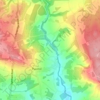
Nom : Carte topographique Plaxtol, altitude, relief.
Lieu : Plaxtol, Tonbridge and Malling, Kent, England, United Kingdom (51.24646 0.27757 51.28497 0.33605)
Altitude moyenne : 100 m
Altitude minimum : 36 m
Altitude maximum : 167 m
Autres cartes topographiques
Cliquez sur une carte pour visualiser sa topographie, son altitude et son relief.
Ightham Common
United Kingdom > England > Kent > Tonbridge and Malling > Ightham
Altitude moyenne : 145 m
Barden Lake
United Kingdom > England > Kent > Tonbridge and Malling > Tonbridge
Altitude moyenne : 33 m
Kit's Coty
United Kingdom > England > Kent > Tonbridge and Malling > Bluebell Hill
Altitude moyenne : 102 m
Holborough Lakes
United Kingdom > England > Kent > Tonbridge and Malling > Snodland
Altitude moyenne : 32 m
Beltring
United Kingdom > England > Kent > Tonbridge and Malling > East Peckham
Altitude moyenne : 15 m
Pratling Street
United Kingdom > England > Kent > Tonbridge and Malling > Aylesford > Pratling Street
Altitude moyenne : 49 m
Royal British Legion Village
United Kingdom > England > Kent > Tonbridge and Malling
Altitude moyenne : 33 m
Bradbourne
United Kingdom > England > Kent > Tonbridge and Malling > East Malling
Altitude moyenne : 28 m